Recent highly pathogenic avian influenza (HPAI) outbreaks have reminded livestock producers how important it is to have solid biosecurity plans in place. To make that easier, the National Farm Medicine Center has launched PremisesMapper, a free online tool that helps producers create premises maps.
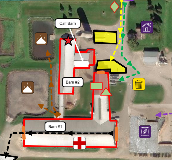
A premises map is a key element of any biosecurity plan. Premises maps show features like lines of separation, access points, cleaning stations, carcass disposal routes, and other biosecurity elements. Many producers must submit these maps to their state animal health office during a disease response, and having one ready ahead of time can expedite response efforts and help producers maintain continuity of business during an outbreak.
Until now, maps were often made using Google Earth screenshots paired with Microsoft Word shapes, or even hand‑drawn sketches. PremisesMapper replaces that with an intuitive interface where users can place icons, draw outlines and routes, and follow a step‑by‑step guide based on existing premises mapping best practices.
Early users say the tool saves time and streamlines communication during HPAI response efforts. “It’s a definite time saver,” said Kurt Grajkowski, emergency services coordinator with the Wisconsin Department of Agriculture, Trade, and Consumer Protection (DATCP) Division of Animal Health. “We had some changes to one of our premises just the other day, and I was able to make the updates in a matter of minutes.”
Producers can create a free account and start mapping here: https://rfdash.org/PremisesMapper/
Questions? Contact jakob.hanschu@sanfordhealth.org